


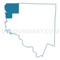
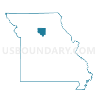
Cunningham Voting District, Chariton County, Missouri
About
Outline

Summary
| Unique Area Identifier | 607461 |
| Name | Cunningham Voting District |
| County | Chariton County |
| State | Missouri |
| Area (square miles) | 61.90 |
| Land Area (square miles) | 57.73 |
| Water Area (square miles) | 4.17 |
| % of Land Area | 93.26 |
| % of Water Area | 6.74 |
| Latitude of the Internal Point | 39.64474440 |
| Longtitude of the Internal Point | -93.20525620 |
Maps

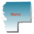
Graphs
Select a template below for downloading or customizing gragh for Cunningham Voting District, Chariton County, Missouri


Neighbors
Neighoring Voting District (by Name) Neighboring Voting District on the Map
- Brookfield Voting District, Linn County, MO
- Brunswick Voting District, Chariton County, MO
- Grand River Voting District, Livingston County, MO
- Hurricane Voting District, Carroll County, MO
- Jefferson Voting District, Linn County, MO
- Mendon Voting District, Chariton County, MO
- Parsons Creek Voting District, Linn County, MO
- Yellow Creek Voting District, Chariton County, MO
Top 10 Neighboring County Subdivision (by Population) Neighboring County Subdivision on the Map
- Brookfield township, Linn County, MO (5,208)
- Parson Creek township, Linn County, MO (856)
- Jefferson township, Linn County, MO (725)
- Hurricane township, Carroll County, MO (701)
- Yellow Creek township, Chariton County, MO (369)
- Mendon township, Chariton County, MO (308)
- Grand River township, Livingston County, MO (250)
- Cunningham township, Chariton County, MO (217)
- Triplett township, Chariton County, MO (163)
Top 10 Neighboring Place (by Population) Neighboring Place on the Map
Top 10 Neighboring Unified School District (by Population) Neighboring Unified School District on the Map
- Brookfield R-III School District, MO (6,503)
- Meadville R-IV School District, MO (1,279)
- Northwestern R-I School District, MO (1,032)
- Hale R-I School District, MO (800)
Top 10 Neighboring State Legislative District Lower Chamber (by Population) Neighboring State Legislative District Lower Chamber on the Map
- State House District 7, MO (34,548)
- State House District 22, MO (34,437)
- State House District 8, MO (33,540)
Top 10 Neighboring State Legislative District Upper Chamber (by Population) Neighboring State Legislative District Upper Chamber on the Map
Top 10 Neighboring 111th Congressional District (by Population) Neighboring 111th Congressional District on the Map
Top 10 Neighboring Census Tract (by Population) Neighboring Census Tract on the Map
- Census Tract 4801, Livingston County, MO (3,652)
- Census Tract 4802, Livingston County, MO (3,193)
- Census Tract 4903, Linn County, MO (3,000)
- Census Tract 4702, Chariton County, MO (2,534)
- Census Tract 9601, Carroll County, MO (2,530)
- Census Tract 4701, Chariton County, MO (2,372)
- Census Tract 4902, Linn County, MO (2,300)
Top 10 Neighboring 5-Digit ZIP Code Tabulation Area (by Population) Neighboring 5-Digit ZIP Code Tabulation Area on the Map
- 64628, MO (6,144)
- 64643, MO (1,072)
- 64659, MO (964)
- 64651, MO (570)
- 64688, MO (548)
- 64660, MO (513)
- 64676, MO (215)
- 64681, MO (192)
- 65286, MO (129)